The Largest Conventional, Measured & Indicated Uranium Deposit in the U.S.
Sound fundamentals underpin the Project
PROJECT OVERVIEW
Substantial size
32.75Mlbs Indicated | 4.98Mlbs Inferred
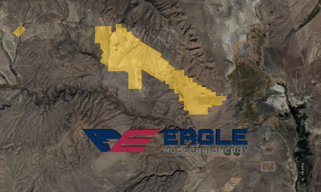
AURORA PROJECT
Prolific region with world class mining infrastructure
Situated within Malheur County in Southeastern Oregon, in the Quinn River Valley. The site is 3 miles (4.8 kilometers) from the Nevada border and approximately 6 miles (9.7 kilometers) west of McDermitt, Nevada. Nevada is frequently ranked as one of the most mining-friendly jurisdictions globally by the Fraser Institute.

The 2025 Resource estimate is based on the interpretation of geological observations from detailed historical drilling. A total of 675 drillholes (including both diamond and rotary holes) were used to define the resource.
The exploratory data analysis was conducted on raw drillhole data to determine the nature of the element distribution, correlation of grades within individual lithologic units, and the identification of high-grade outlier samples. A combination of descriptive statistics, histograms, probability plots, and X-Y scatter plots were used to analyze. Collectively, this information was used to produce an initial classification script followed by manual wireframe application to further limit the mineral resource classification.
(Swipe table L-R to view)
|
Classification
|
Deposit
|
Cut-Off Grade
(ppm U3O8) |
Tonnage
(Mt) |
Grade
(U3O8 ppm) |
Contained Metal
(U3O8 Mlb) |
|---|---|---|---|---|---|
|
Indicated
|
Aurora
|
100
|
53.42
|
278
|
32.75
|
|
Inferred
|
Aurora
|
100
|
8.96
|
252
|
4.98
|
For additional details, please review SK1300 Technical Report Summary
Leveraging a defined uranium resource, extensive drilling data, existing infrastructure, and access to low-cost hydropower to efficiently advance a strategically located project through a supportive permitting environment.
To review our entire interactive project presentation, please click the image to the right.
To review our entire interactive project presentation, please click the image below.
The Aurora uranium property is located within the Miocene McDermitt caldera system, spanning the border between Oregon and Nevada. The McDermitt caldera spans approximately 30 miles (48 kilometers) north to south and 20 miles (32 kilometers) east to west, with five nested ring fracture systems.
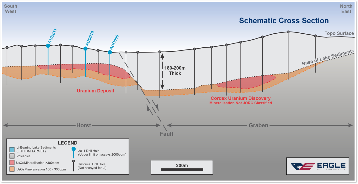
The Aurora Project area is covered by a thin layer of alluvium over lakebed sediments, which unconformably overlie interbedded dacite/rhyolite lava flows, tuffaceous units, pyroclastic breccia, and local fault breccia. The lake sediments are Miocene in age and up to 600 feet (183 meters) thick in the drillholes, being thickest on the north edge of the mineralized zone in a graben-like growth basin. The sediments probably originated from local volcanic vents and were deposited in moat-like basins within the caldera margins.
Aurora project regional geology within McDermott caldera system
Alteration is mainly clay, with opaline or chalcedonic silica, chlorite, gypsum, fluorite, and zeolites.
Mineralization is associated with the porous and permeable volcanic rocks and includes pyrite-bearing clays with uranium minerals, leucoxene, marcasite, and arsenopyrite. Uranium minerals have been identified to include uraninite, coffinite, phosphorylite, umohoite and autunite (hydrous calcium uranium phosphate.
The mineralization at Aurora uranium forms stratabound and cross-cutting bodies in the lake sediments and dacitic flow units, forming an irregular mineralized zone approximately 5,000 feet (1,524 meters) long by 1,000 feet (305 meters) wide.
The mineralized horizons range from a true thickness of a few feet to more than 100 feet (30.5 meters) thick. The mineralized beds are nearly horizontal to moderately dipping, up to 40°. The beds are spatially related to, and partially controlled by, possible growth faults or graben bounding structures, primarily on the northeast margin of the mineralization. The diamond drill core logs show that the uranium mineralization includes some primary deposition associated with volcanic and hydrothermal activities. The spatial distribution of uranium within sediments and broken, permeable zones of volcanic rocks suggests mechanically and chemically transported zones of mineralization are common. Several of the secondary or tertiary basins, within the lake sediments and graben block, show thin repeating beds of mineralization, within zones of the more permeable rocks, which are isolated by clay-rich zones. Thicker and higher-grade mineralization may indicate high angle structures that served as hydrothermal feeders or enrichment zones. Drillhole AUR_DDH-495 is the only angle core hole and confirms the approximately horizontal nature of the mineralization.
Geologic analysis shows moderate and low-grade mineralization (<0.05% or 500 ppm eU3O8) has lateral continuity, while high-grade mineralization (>0.08% or 800 ppm eU3O8) is sporadic. Local feeder zones may explain this uneven high-grade distribution. High-grade areas have not been tested with angled drilling. Exploring these zones could boost the overall average grade of mineralization.
Volcanic-type uranium deposits are mineralized systems that are associated with volcanic rocks in a caldera setting. These deposits are typically found within mafic to felsic volcanic rocks and are often mixed with clastic sediments. The mineralization is primarily structure-controlled, occurring at various stratigraphic levels of the volcanic and sedimentary units, and extending into the basement where it is in fractured granite and metamorphic rocks. Hydrothermal processes strongly influence the transport of uranium, leading to both primary and remobilized uranium mineralization in an oxidizing-reducing environment.
Uranium mineralization is often found alongside molybdenum, vanadium, lithium, other sulfides, violet fluorite, and quartz to colloidal silica or opal.
Examples of volcanic-hosted uranium deposits include the Dornot deposit in Mongolia, the Michelin deposit in Canada, the Nopal deposit in Mexico, and several commercial deposits in the Strelsovsk Caldera in the Russian Federation.
In mid-May 2011 a high-sensitivity aeromagnetic radiometric survey over the Aurora Deposit and surrounds was undertaken.
Aircraft equipment included a cesium vapor, digitally compensated magnetometer, a 1024 channel spectrometer, a GPS real-time and post-corrected differential positioning system, a flight path recovery camera, digital titling and recording system, as well as radar and barometric altimeters.
All data was recorded digitally in GEDAS binary file format. Reference ground equipment included a GEM Systems GSM-19W Overhauser magnetometer and a Novatel 12-channel GPS base station which was set up at the base of operations for differential post-flight corrections.

A total of 2,070 line kilometers of high resolution magnetic and radiometric data was collected, processed and plotted. The traverse lines were flown east-west on a spacing of 100 meters, with perpendicular control lines flown at a separation of 1,000 meters.
Shallow & Near-Surface Deposit
Aurora Deposit: Cost Effective – Low Risk
Historical Drilling
The bulk of the drilling on the Aurora Deposit was conducted prior to 1980, during which Jacobs and Placer completed an extensive program of rotary and diamond drilling (at least 90 drillholes in 1977 and 1978 totaling about 9,945 m). The initial drilling program intersected a flat-lying mineralized zone, which in places was over 30 m thick and assay averages were approximately 0.05% eU3O8 (Roper, 1979). Eagle possesses a comprehensive record of this drilling, including associated radiometric and geological logs, which have been utilized to strategically plan the locations for holes in the current drilling program. In 1979, Placer completed approximately 447 rotary drillholes totaling about 46,205 m, as well as 25 diamond drillholes totaling about 2,027 m. Drillholes are spaced 100 feet apart on lines spaced 200 feet apart. Drill lines are orientated N042°E; a local grid was used. This spacing equates to 60 m x 30 m.
From January to July 2011, a total of 32 vertical diamond drillholes and six RC holes were drilled by EVE at the Aurora Deposit. Drilling was done to obtain further information on the uranium grade and continuity, confirm historical radiometric readings and grade conversions, refine the geological model for the deposit, and obtain samples for metallurgical testing.
In November 2022, 17 drillholes were completed by Aurora Energy Metals. Five of the drillholes were done using diamond drilling for a total of 1,118 meters, and 12 holes were completed utilizing RC drilling for a total of 2,296 meters.
Historical Drilling
The ‘Cordex Syndicate’ drilled 110 holes on claims adjacent to the Aurora Deposit, also between 1978 and 1980
Combined total for both Aurora and Cordex include 727 diamond drill (DDH) and reverse circulation (RC) holes comprising 290,975’ (88,689 m).
(Swipe table L-R to view)
|
Company
|
Hole Type
|
No. Holes
|
Feet
|
Meters
|
|---|---|---|---|---|
|
Jacobs 1978
|
RC
|
90
|
32,630
|
9,946
|
|
Placer
|
RC
|
447
|
151,590
|
46,205
|
|
1978-1979
|
DDH
|
25
|
6,650
|
2,027
|
|
Subtotal
|
562
|
190,870
|
58,178
|
|
|
EVE
|
DDH
|
32
|
13,966
|
4,257
|
|
2011
|
RC
|
6
|
3,115
|
949
|
|
2022
|
RC/DDH
|
17
|
11,202
|
3,414
|
|
Subtotal
|
55
|
28,283
|
8,620
|
|
|
Total
|
617
|
219,153
|
66,798
|
|
|
ADJACENT AREAS
|
||||
|
Cordex
|
RC
|
101
|
65,290
|
19,900.4
|
|
1978-1980
|
DDH
|
9
|
6,532
|
1,990.9
|
|
Subtotal
|
110
|
71,822
|
21,891.3
|
|
Collar Surveys
Drillhole coordinates were provided in a local coordinate system measured in feet. A grid conversion was setup to convert all data to WGS84 UTM zone 11N using two common points. Collar positions were measured using handheld GPS in UTM Zone 11N, WGS84 datum.
(Swipe table L-R to view)
|
|
Local East
|
Local North
|
UTM East
|
UTM North
|
|---|---|---|---|---|
|
Pt A
|
10000.000
|
11000.000
|
424572.714
|
4654002.612
|
|
Pt B
|
10000.000
|
10000.000
|
425315.859
|
4653333.481
|
|
Pt C (calculated)
|
10248.631
|
10723.868
|
424944.287
|
4654002.612
|
Operational Milestones
Met Testing & Exploration
Pre-feasibility Preparation
Pre-feasibility Completion
Commissioning & Production
Permitting Milestones
Baseline
Studies
BLM Permit Submission
DOGAMI Permit Submission
Federal Agency Coordination
Regarding historical data, sample preparation, data verification, analysis & security as well as mineral processing and metallurgical testing and expanded information regarding the Aurora Mineral Resource Estimate (MRE) please review our SK1300 Technical Report as of August 8, 2025 authored by BBA USA Inc.
To review our entire interactive project presentation, please click the image to the right.
To review our entire interactive project presentation, please click the image below.